Posts

Showing posts from June, 2017

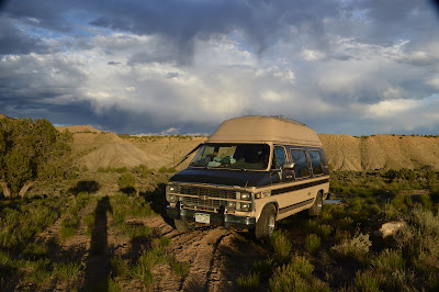
Burnt Cabin Gulch FR 060 Ashley NF Vernal Utah

Image
  Just some flat grasslands above Burnt Cabin Gulch, 2wd van access high clearance recommended, good Cricket service and a 16 day limit. Cow pond nearby. I came in on 217 and passed a dozen or so Travel Trailers and RVs but at my campsite all I saw was a group of dirtbikes and a sideXside.    Ponderosa pines, shrub oak(?could be wrong?) and aspen groves a short walk away. 40°39'55.9"N 109°25'06.0"W  

Near Dinosaur National Monument and Utah border - Moffat County Colorado

Image
   Another peaceful campsite in Colorado. Located just down the road from some campsites listed on Campendium. 2wd van accessible without any clearance or traction issues, RVs are maybe. Not much to say other than there as a fire ring, some trash and like most of the public land is open range so there was cows, one particularly annoying bull and a couple cattleman rode past on.    Good service with Cricket 40°21'25.0"N 109°01'19.9"W

Memorial day hidey hole - BLM land North of Loma CO

Image
   I anted to avoid all human contact through the busy holiday weekend so I carefully mapped out a camp, a dead end road near some abandoned or capped oil wells. Nobody should be up there and I did get the full 8 days of peace and quite.    Again I go camping in the oilfield, there's many reasons I do this to myself. Starting with access, these roads, or former roads are cut to get a drilling rig in so when it's dry a 2wd van can get in, if you do see someone they aren't there to socialize they just want to do their job and go home.    Now camping in the oilfield has it's drawbacks, one is that you see firsthand the destruction to our public lands caused by oil corporations, out own citizens and the agencies that are supposed to protect the land, I digress..... 39°23'01.7"N 108°47'48.5"W Here look at some photos: